Posts

Showing posts from August, 2020
Image
25. Map of the Borough of Plymouth Title: Borough Of Plymouth , Date: 1820. Size: 220 x 295 mm. Imprint(s): Pubd April 15. 1820. by Mrs E Nile, No. 48 Union St, Stonehouse with price (1s 6d) and ENGRAVING & COPPER-PLATE PRINTING OFFICE (below). Signature(s): Engraved By John Cooke (in title panel). Location(s): NLS ,  BL ,  BnF ,  DevA, WDRO . [1]   Comments: Below the title is a dedication on a tablet in vignette (Da) to the Mayor, Commonalty and Inhabitants signed by John Cooke, Engraver . The inclusion of the price makes it apparent that the map was sold separately (cost 1s 6d). However, three copies (i.e. at NLS and BL as well as in a private collection) of Interesting Particulars, relative to that Great National Undertaking, the Breakwater, a joint publication of John Cooke in Stonehouse and J Johns of Plymouth Dock include this map (see entry 28 ). [2] This is the first map to show only Plymouth and, although the houses are shown as blocks and not individually, is
Image
26. Plan of the Three Towns drawn by S Elliott 26.1. Title: Plan Of The Towns & Harbour Of Plymouth, Dock, Devonport, Morice-Town, Stoke , And The Environs, In The County Of Devon . Date: 1820. Size: 375 x 515 mm. Imprint(s): Survey'd Drawn & Published by S Elliott. Landsurveyor &c Orchard Place Plymouth. Signature(s): Engraved by John Cooke, Stonehouse, Plymouth, 1820. Location(s): WDRO [1] , DoC [2] , KB .    Comments: The second plan published in 1820, this is only one of two maps of the town(s) where we can be sure of the surveyor. T Richards of Totnes was responsible for the 1810 Dock plan and S Elliott is given here as Land Surveyor and the publisher of the map. [3] He also surveyed and drew the plan of Edgcumbe Park ( 24A ). In this map all three towns are shown for the first time since the 1817 chart but this plan clearly shows the urban area whereas the chart was possibly for mariners. The area of Dock is similar to that in Cooke´s previous plans but th
Image
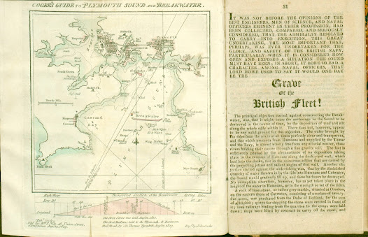
27. Map of Plymouth also showing cross-section of the Breakwater 27.1. Title: Cooke’s Guide To Plymouth Sound And Breakwater .   Date: 1819 [1821]. Size: 150 x 140 mm inside border (185 mm total). Imprint(s): Pub d for & sold by M rs E Nile, 48, Union Street, Stonehouse, Aug 12, 1819. Signature(s): Eng d by John Cooke. Location(s): NLS, KB. [1]   Comments: A much simplified plan of the three towns but still similar in some ways to the chart of 1817 with a plan of the breakwater below it. Although dated 1819 the first examples seen were included in a later work. Two copies found in editions of Interesting Particulars, relative to that Great National Undertaking, the Breakwater, Plymouth Dock; J Johns: Stonehouse; John Cooke. (1821). Note: some copies of this work have a different map, Borough of Plymouth (see 25 above). Below the bottom border is a Transverse section of the Breakwater and note on first stone being laid in 1812 and two further lines of text referri
Image
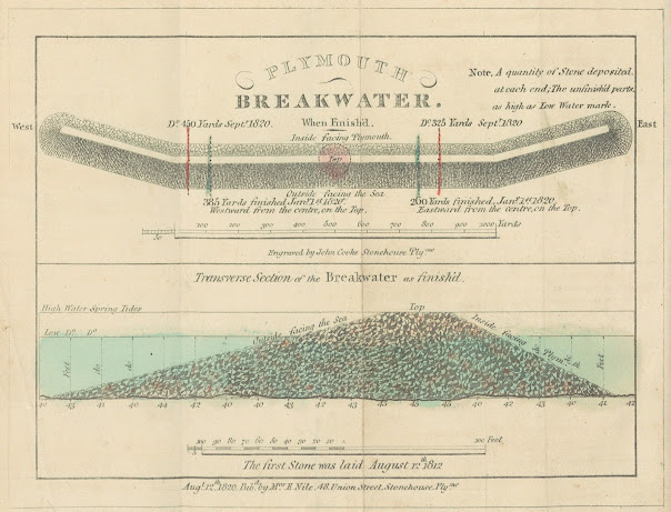
28. First Plans of the Breakwater 28. Title: Two plans of the breakwater being built at Plymouth. The upper plan: PLYMOUTH BREAKWATER. When finished . The lower plan: Transverse section of the Breakwater as finish'd. Date: 1820 [1821]. Size: 125 x 172 mm. Imprint(s): ): Aug t 12 th 1820.   Pub d by M rs E Nile, 48 Union Street, Stonehouse, Ply mo under complete plan . Signature(s): Engraved by John Cooke Stonehouse Ply mo . Location(s):  BL ,  NLS ,  KB , P, ( DevA ). [1]   Comments: This plan was included in Interesting Particulars, relative to that Great National Undertaking, the Breakwater, published in   Plymouth Dock by J Johns and also in Stonehouse by John Cooke. The signature is below upper scale: Scale is 50 + 1000 yards to 102 mm. Lower Scale is 100 + 100 feet is 85 mm. [2] The Interesting Particulars is in a rather slim, but nevertheless, interesting publication. The first section is devoted to reprinting earlier texts such as the original report of Joh
Image
29. Map of the area around Plymouthfor 12 miles 29.1 Title: Map Of The Country Twelve Miles Round Plymo DOCK   in circular panel. Date: 1821. Size: 220 x 285 mm. Imprint(s): none . Signature(s):   none . Location(s): P .    Image copyright Celsus Books Comments: The Panorama of Plymouth by Samuel Rowe appeared in 1821 . Rowes (i.e. Rowe´s) would be the publisher Samuel Rowe (1793-1853) who was the son of an affluent local farmer. He had no desire to follow in his father´s footsteps and after a grammar school education and an apprenticeship in Kingsbridge he ran a bookshop in Plymouth. He went on to become a noted antiquary, being one of the first members (and one of the first secretaries) of the Plymouth Athenaeum, and to write what became the standard work on Dartmoor, his  Perambulations . Later on in life he would become first minister in the church of St Paul at Stonehouse. The scale is established by 5-mile squares and numbering along the borders. It s hows the
Image
30. Cooke´s Second Breakwater Plans 30.1. Title: Two plans of the breakwater at Plymouth. The upper plan: COOKE’S PLYMOUTH BREAKWATER . The lower plan: TRANSVERSE section of the Finished part of the BREAKWATER . Date: 1823. Size: 190 x 320 mm. Imprint(s): see signature. Signature(s): Taken , Engraved and Published by John Cooke 48, Union Street, Stonehouse, Plymo and dated August 21 st 1823 . Location(s): BL. [1]   Comments: This second sheet with two plans of the breakwater has a  scale of 1000 yards = 170 mm for the upper plan (from above) and a scale of 100 + 100 feet = 135 mm (tranverse section). There is an added note: The first stone was laid August 12 th 1812.   This map first appeared in 1823, possibly as a single sheet plan. This is a much larger and much changed variation of Cooke´s first breakwater plan (see 28 above which is 125 x 172 mm). The breakwater is now seen from the other side and there is more detail (e.g., hatching is designed to show sta
Image
31. Chart of Plymouth Sound with the Three Towns Title: Cooke’s Chart of Plymouth Sound, and General Guide to Plymouth, Devonport and Stonehouse   in panel slightly right of top centre. Date: 1824. Size: 540 x 420 mm. Imprint(s): Published Oct r 25, 1824 by JOHN COOKE ENGRAVER & GEOGRA R and there is the added information that Cooke was (late engraver to the Admiralty) 48, Union St., Stonehouse Plym o . Signature(s): see above. Location(s):  BL,   NMM,   WDRO,   KB . [1] Comments: There is a note above top border: UNDER THE patronage OF THE CHAMBER OF COMMERCE, PLYMOUTH . Further imprint (right of title): Entered at Stationer´s Hall, London. Price 3s 6d. Border on three sides, no border at bottom. This is a fairly large and detailed chart covering an area from the entrance of the Lynher (Aa) to just east of Efford (Ea) with Rame Head (Ae) and the Mewstone in border (Ee). The breakwater appears virtually central. On the one hand, it is a mariner´s chart with much informa
Image
32. Cooke´s Pocket Plan of the Three Towns 32. Title: COOKE`S STRANGER`S GUIDE OR POCKET PLAN of the three Towns OF PLYMOUTH, DEVONPORT AND STONEHOUSE. Date: 1827. Size: 260 x 365 mm. Imprint(s): Pubd Octr 1st 1827 by John Cooke 82 Union Street Stonehouse Plymo. Pr. 1s.6d. – Entd at Stationers Hall. Signature(s): See imprint. Location(s): see below. [1]     Comments: Attractive triangular patterned border. This is both a more detailed and an untidier looking map. Cooke or the artist who drew the plan has attempted to show more landscape features and there is a large amount of hill shading as well as hachuring along the coast. The Block House is now sat upon a small hill. Coastal shading has been included around Dock and there are large outcrops of rock in the harbour at the mouth of Mill Bay. Urban development is shown and Stoke and New Town are taking shape. The Gas Works appear just before Stonehouse. Note the sudden change of direction of the Dartmoor Railway as well as the coat
Image
33. Large map of Plymouth and surrounding areas 33.1. Title: THE ENVIRONS OF PLYMOUTH DEVONPORT AND STONE HOUSE. Added title below this: A Companion to the Different Guides of the Neighbourhood . The title itself is within a lozenge (Ae) with two notes within its borders: on 4 Plates (top) and to Subs.5s. Sellg. Pr. 7s (bottom). Date : [1828]. Size : Printed on four plates, each c. 246 x 273 mm. When combined map size is c. 485 x 550 mm. Imprint(s) : Engraved & Sold by John Cooke Union Stt Stonehouse below title in lozenge. Signature(s) : see above. Location(s) : see below. Comments: This completed map is made up of four sheets (Plates) as described in John Cooke´s Proposals and in his letter to the Mayor, Pridham. Each plate has a piano key border on two sides and a plain two-line border on the ‘joining’ sides. A note above the border reads PLATE. 1. (2, 3, or 4). Scale of Statute Miles (2 = 49 mm) below title lozenge. PLATE.1 - Portwrinkle to the Mew Stone and north to St Bu