Posts

Showing posts with the label breakwater
Image
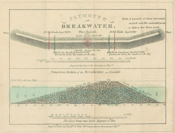
27. Map of Plymouth also showing cross-section of the Breakwater 27.1. Title: Cooke’s Guide To Plymouth Sound And Breakwater .   Date: 1819 [1821]. Size: 150 x 140 mm inside border (185 mm total). Imprint(s): Pub d for & sold by M rs E Nile, 48, Union Street, Stonehouse, Aug 12, 1819. Signature(s): Eng d by John Cooke. Location(s): NLS, KB. [1]   Comments: A much simplified plan of the three towns but still similar in some ways to the chart of 1817 with a plan of the breakwater below it. Although dated 1819 the first examples seen were included in a later work. Two copies found in editions of Interesting Particulars, relative to that Great National Undertaking, the Breakwater, Plymouth Dock; J Johns: Stonehouse; John Cooke. (1821). Note: some copies of this work have a different map, Borough of Plymouth (see 25 above). Below the bottom border is a Transverse section of the Breakwater and note on first stone being laid in 1812 and two further lines of tex...
Image
28. First Plans of the Breakwater 28. Title: Two plans of the breakwater being built at Plymouth. The upper plan: PLYMOUTH BREAKWATER. When finished . The lower plan: Transverse section of the Breakwater as finish'd. Date: 1820 [1821]. Size: 125 x 172 mm. Imprint(s): ): Aug t 12 th 1820.   Pub d by M rs E Nile, 48 Union Street, Stonehouse, Ply mo under complete plan . Signature(s): Engraved by John Cooke Stonehouse Ply mo . Location(s):  BL ,  NLS ,  KB , P, ( DevA ). [1]   Comments: This plan was included in Interesting Particulars, relative to that Great National Undertaking, the Breakwater, published in   Plymouth Dock by J Johns and also in Stonehouse by John Cooke. The signature is below upper scale: Scale is 50 + 1000 yards to 102 mm. Lower Scale is 100 + 100 feet is 85 mm. [2] The Interesting Particulars is in a rather slim, but nevertheless, interesting publication. The first section is devoted to reprinting earlier texts such as t...
Image
30. Cooke´s Second Breakwater Plans 30.1. Title: Two plans of the breakwater at Plymouth. The upper plan: COOKE’S PLYMOUTH BREAKWATER . The lower plan: TRANSVERSE section of the Finished part of the BREAKWATER . Date: 1823. Size: 190 x 320 mm. Imprint(s): see signature. Signature(s): Taken , Engraved and Published by John Cooke 48, Union Street, Stonehouse, Plymo and dated August 21 st 1823 . Location(s): BL. [1]   Comments: This second sheet with two plans of the breakwater has a  scale of 1000 yards = 170 mm for the upper plan (from above) and a scale of 100 + 100 feet = 135 mm (tranverse section). There is an added note: The first stone was laid August 12 th 1812.   This map first appeared in 1823, possibly as a single sheet plan. This is a much larger and much changed variation of Cooke´s first breakwater plan (see 28 above which is 125 x 172 mm). The breakwater is now seen from the other side and there is more detail (e.g., hatching is design...
Image
31. Chart of Plymouth Sound with the Three Towns Title: Cooke’s Chart of Plymouth Sound, and General Guide to Plymouth, Devonport and Stonehouse   in panel slightly right of top centre. Date: 1824. Size: 540 x 420 mm. Imprint(s): Published Oct r 25, 1824 by JOHN COOKE ENGRAVER & GEOGRA R and there is the added information that Cooke was (late engraver to the Admiralty) 48, Union St., Stonehouse Plym o . Signature(s): see above. Location(s):  BL,   NMM,   WDRO,   KB . [1] Comments: There is a note above top border: UNDER THE patronage OF THE CHAMBER OF COMMERCE, PLYMOUTH . Further imprint (right of title): Entered at Stationer´s Hall, London. Price 3s 6d. Border on three sides, no border at bottom. This is a fairly large and detailed chart covering an area from the entrance of the Lynher (Aa) to just east of Efford (Ea) with Rame Head (Ae) and the Mewstone in border (Ee). The breakwater appears virtually central. On the one hand, it is a mariner´s...
Image
36. Cooke´s Third Breakwater plans 36.1.  Title: Two plans of the breakwater. The upper plan: COOKE’S PLYMOUTH BREAKWATER. The lower plan: TRANSVERSE Section of the BREAKWATER. Date: 1843. Size:  (255 x 300 mm.) Imprint(s): Engraved & Published by John Cooke June ( )th 1843, 82 Union Street, Stonehouse, Plymo. Signature(s): Mr Cooke Engraver, 82, Union Street Stonehouse. with below Map & Chart Engraver and Geographer Extraordinary to / to (sic) His late Majesty William IVth – in his 80th year of age. Location(s): Unknown but probably Devon Archives. [1] Comments: This is the last of Cooke´s Breakwater plans. It has two scales: upper scale, the  breakwater from above,  is 100 + 1000 yards (172 mm); lower scale, a  transverse section,  is 100 + 100 feet (135 mm). The original imprint is difficult to read as there is elaborate scrollwork around it. The plan  clearly  shows the lighthouse and there is only a small section (coloured blue) ...