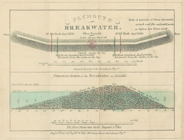
28. Title: Two plans of the breakwater being built at Plymouth. The upper plan:
Date: 1820 [1821].
Size: 125 x 172 mm.
Comments: This plan was included
in Interesting Particulars, relative to
that Great National Undertaking, the Breakwater, published in
The
Interesting Particulars is in a
rather slim, but nevertheless, interesting publication. The first section is
devoted to reprinting earlier texts such as the original report of John Rennie
and Joseph Whidbey to the Lords Commissioners of the Admiralty from April 21st
1806. This is given verbatim and takes the bulk of the work. The Interesting Particulars always contains this plan but copies seen have two different extra maps bound in (see 25 and 27).
The
Estimate which follows puts the projected cost at just over 1 million pounds
making it probably the most expensive project of this type known. A Further
Report by Rennie to the commissioners follows. After a letter from Mr Rennie to
J W Croker of April 15th 1811 there is a further estimate signed by
W Fawkener. The only section representing a contribution by the authors seems
to be the final four pages with a rather sensational Grave of the Fleet! in very
large letters dominating the opening page.
Interesting Particulars, relative to ... the Breakwater.
Plymouth Dock; J Johns: Stonehouse; John Cooke. 1821.[3]
[1] Another copy is
at the National Archives at Kew (MPH 1/287/3) filed together with papers
preparing for Dawson’s work on the boundary changes of 1832.
[2] Note that some libraries catalogue this under Rennie and Whidbey as the text of their report is reprinted together with extracts from a government report of 1812. The two maps were completed 1819 and 1820, but there is an Advertisement dated January 1821. The NLS and BL copies both have the Borough map of Plymouth bound in.
[3] Preface dated January, 1821


No comments:
Post a Comment