Posts

Showing posts with the label Plymouth
Image
  Summary   As can be seen from the works quoted, Cooke was certainly resident at various London addresses until circa 1812 and his work there is fairly well documented. We have a large number of published work and accompanying some of these, such as the Circular Atlas , the Universal Atlas and the Synopsis of Geography , we have newspaper advertisements and reviews. We can trace his movements from his various addresses and we have evidence that, in common with many sole traders of the times, he was twice imprisoned for short periods for debt. Besides the three works mentioned above, one of Cooke´s final two works, the smaller scale version with “London” as his address of the large map for the St Aubyn family, reappear with a west country connection. All work by John Cooke before 1812 has a London address including the original map for the St Aubyn family. Obviously in order to engrave the map, Cooke did not need to visit Plymouth but something sparked an interest in the west...
Image
19. Map of Plymouth Dock for the St Aubyn family 19. Title: A Plan Of The Town Of Plymouth Dock, Part Of The Manor Of Stoke Damerell, In The Parish Of Stoke Damerell, In The County Of Devonshire. The Property Of S r John S t , Aubyn, Bar t . Date: 1810. Size: 690 x 620 mm on a sheet 1020 x 680 mm. A Scale o 660 Feet or 1/8 of a Mile   660 Feet = 128 mm. Imprint(s): Surveyed, Drawn, and Published by T. RICHARDS, Totnes, Devon, Oct r . 25 th . 1810 (as part of title). Signature(s): Engraved by John Cooke, London, late Eng r . to the Admiralty. Location(s): McMaster [1] ,  WDRO [2] .   Comments: Loose sheet, printed map showing building lots as shaded areas. The title is in an oval cartouche of oak leaves, with a coat of arms with motto above - IN SE TERRE – and imprint and signature below. [3] The plan is very detailed and shows fairly graphically how Plymouth Dock was residential within a large rectangle surrounded by Dock Wall Street and Chapel Street t...
Image
22. Chart of Plymouth Harbour by Copper Plate Printing Office 22. Title: Chart of the Harbour of Plymouth Taken 1817 . (Title above border centrally, Taken 1817 below this just inside border.) Date:  1817 [1] . Size: 480 x 360 mm. Imprint(s): The Copper Plate Engraving and Printing Office , New Street, Stonehouse, Plm o . Signature(s): None. Location(s):   P . [2] Comments: The chart covers an area from White Sand Bay and Ram Head (Ad) to the Mew Stone (Ed) and the course of the river as far as Tor Point (Bb) and Keyham Lake. It shows depths in the Sound as well as the Breakwater but lacks a bottom border. Tor House has been included beside the title and above the top border  (see illustration below) . Magnetic north is included in the compass rose. On the right is a sketch A of a dry dock with dimensions: Breadth 60 Ft, Depth 18 Ft and Length 160 Feet. This is explained in the Reference (Ea) as a dry dock at Tanchapel (sic); this should be Tu...
Image
25. Map of the Borough of Plymouth Title: Borough Of Plymouth , Date: 1820. Size: 220 x 295 mm. Imprint(s): Pubd April 15. 1820. by Mrs E Nile, No. 48 Union St, Stonehouse with price (1s 6d) and ENGRAVING & COPPER-PLATE PRINTING OFFICE (below). Signature(s): Engraved By John Cooke (in title panel). Location(s): NLS ,  BL ,  BnF ,  DevA, WDRO . [1]   Comments: Below the title is a dedication on a tablet in vignette (Da) to the Mayor, Commonalty and Inhabitants signed by John Cooke, Engraver . The inclusion of the price makes it apparent that the map was sold separately (cost 1s 6d). However, three copies (i.e. at NLS and BL as well as in a private collection) of Interesting Particulars, relative to that Great National Undertaking, the Breakwater, a joint publication of John Cooke in Stonehouse and J Johns of Plymouth Dock include this map (see entry 28 ). [2] This is the first map to show only Plymouth and, although the houses are shown as blocks and no...
Image
26. Plan of the Three Towns drawn by S Elliott 26.1. Title: Plan Of The Towns & Harbour Of Plymouth, Dock, Devonport, Morice-Town, Stoke , And The Environs, In The County Of Devon . Date: 1820. Size: 375 x 515 mm. Imprint(s): Survey'd Drawn & Published by S Elliott. Landsurveyor &c Orchard Place Plymouth. Signature(s): Engraved by John Cooke, Stonehouse, Plymouth, 1820. Location(s): WDRO [1] , DoC [2] , KB .    Comments: The second plan published in 1820, this is only one of two maps of the town(s) where we can be sure of the surveyor. T Richards of Totnes was responsible for the 1810 Dock plan and S Elliott is given here as Land Surveyor and the publisher of the map. [3] He also surveyed and drew the plan of Edgcumbe Park ( 24A ). In this map all three towns are shown for the first time since the 1817 chart but this plan clearly shows the urban area whereas the chart was possibly for mariners. The area of Dock is similar to that in Cooke´s previous plans b...
Image
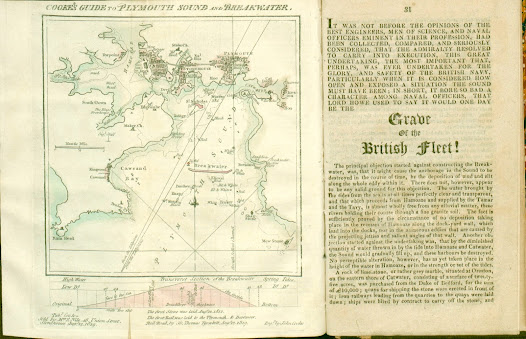
27. Map of Plymouth also showing cross-section of the Breakwater 27.1. Title: Cooke’s Guide To Plymouth Sound And Breakwater .   Date: 1819 [1821]. Size: 150 x 140 mm inside border (185 mm total). Imprint(s): Pub d for & sold by M rs E Nile, 48, Union Street, Stonehouse, Aug 12, 1819. Signature(s): Eng d by John Cooke. Location(s): NLS, KB. [1]   Comments: A much simplified plan of the three towns but still similar in some ways to the chart of 1817 with a plan of the breakwater below it. Although dated 1819 the first examples seen were included in a later work. Two copies found in editions of Interesting Particulars, relative to that Great National Undertaking, the Breakwater, Plymouth Dock; J Johns: Stonehouse; John Cooke. (1821). Note: some copies of this work have a different map, Borough of Plymouth (see 25 above). Below the bottom border is a Transverse section of the Breakwater and note on first stone being laid in 1812 and two further lines of tex...
Image
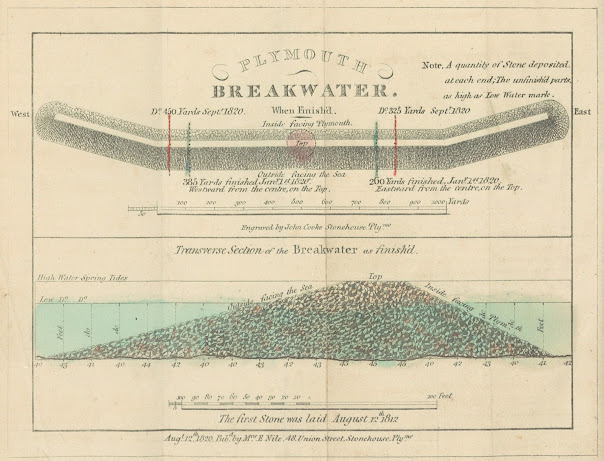
28. First Plans of the Breakwater 28. Title: Two plans of the breakwater being built at Plymouth. The upper plan: PLYMOUTH BREAKWATER. When finished . The lower plan: Transverse section of the Breakwater as finish'd. Date: 1820 [1821]. Size: 125 x 172 mm. Imprint(s): ): Aug t 12 th 1820.   Pub d by M rs E Nile, 48 Union Street, Stonehouse, Ply mo under complete plan . Signature(s): Engraved by John Cooke Stonehouse Ply mo . Location(s):  BL ,  NLS ,  KB , P, ( DevA ). [1]   Comments: This plan was included in Interesting Particulars, relative to that Great National Undertaking, the Breakwater, published in   Plymouth Dock by J Johns and also in Stonehouse by John Cooke. The signature is below upper scale: Scale is 50 + 1000 yards to 102 mm. Lower Scale is 100 + 100 feet is 85 mm. [2] The Interesting Particulars is in a rather slim, but nevertheless, interesting publication. The first section is devoted to reprinting earlier texts such as t...
Image
30. Cooke´s Second Breakwater Plans 30.1. Title: Two plans of the breakwater at Plymouth. The upper plan: COOKE’S PLYMOUTH BREAKWATER . The lower plan: TRANSVERSE section of the Finished part of the BREAKWATER . Date: 1823. Size: 190 x 320 mm. Imprint(s): see signature. Signature(s): Taken , Engraved and Published by John Cooke 48, Union Street, Stonehouse, Plymo and dated August 21 st 1823 . Location(s): BL. [1]   Comments: This second sheet with two plans of the breakwater has a  scale of 1000 yards = 170 mm for the upper plan (from above) and a scale of 100 + 100 feet = 135 mm (tranverse section). There is an added note: The first stone was laid August 12 th 1812.   This map first appeared in 1823, possibly as a single sheet plan. This is a much larger and much changed variation of Cooke´s first breakwater plan (see 28 above which is 125 x 172 mm). The breakwater is now seen from the other side and there is more detail (e.g., hatching is design...