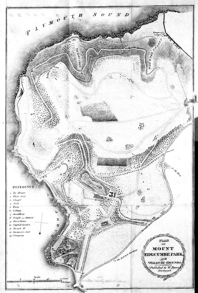
24A. Plan of Edgcumbe Park for a Tourist Guide

24A. Title: PLAN OF MOUNT EDGCUMBE PARK, AND PLEASURE GROUNDS. (Ee in laurel wreath, bottom right).
Date: 1819.
Size: 325 x 215 mm. Scale (20 Chains or 2 Furlongs = 65 mm).
Imprint(s) (within title wreath): Engraved by John Cooke, Stonehouse. 1819.
Signature(s) (below title wreath): Surv'd & Drawn by S Elliott.
Location(s): See below.


Comments: The very well executed plan was surveyed and drawn by S Elliott (see also Plan of the Town and Harbour of Plymouth Dock, 26) and shows the complete park from the landing quay for the Cremill Ferry (Be) as far as the church (Eb, across the border). There is a Reference key (Ad).
The guide A Walk Round Mount Edgcumbe was possibly written as early as 1807[1]. This became a popular guide to the manor and gardens and is referred to in The Picture of Plymouth by Henry Woollcombe, 1812, who mentions the guide as a primary source in the preface: it gave a plain and accurate account of the various objects of this beautiful spot. The complete text as included in The Tourist’s Companion published from 1823 (see 20.2), as acknowledged in the initial Advertsement.
The only further work by Elliott known is alluded to by M W Beresford and was a comprehensive survey of the Duchy of Cornwall in 1819.[2] 

In A Walk Round Mount Edgcumbe. Sixth Edition, with alterations and additions.
Devonport. Congdon and Hearle. 1819.  Gl.
 
A Walk Round Mount Edgcumbe. Seventh Edition, ...
Devonport. Congdon and Hearle. 1821. V&A, LL, BL, Bod, P, BL, DEI.
 
A Walk Round Mount Edgcumbe. Ninth Edition, ...
Devonport. Congdon and Hearle. 1831.   Bl.


Later editions:

24A.2 Title: PLAN OF MOUNT EDGCUMBE PARK, AND PLEASURE GROUNDS.
Date: 1835.
Size: 325 x 215 mm. Scale (20 Chains or 2 Furlongs = 65 mm).
Imprint(s): Published by W. Byers Devonport.
Signature(s): Surv'd & Drawn by S Elliott.
 
24A-2. 1836
In A Walk Round Mount Edgcumbe.  Ninth Edition.
Devonport. W Byers. 1836.   NT.
 
In A Walk Round Mount Edgcumbe.  Tenth Edition.
Devonport. W Byers. 1837.   BL.
 
24A-3.  1840
Date: undated.
Imprint(s): Published by W. Byers Devonport.
Signature(s): none.
 
In A Walk Round Mount Edgcumbe.  11th Edition.
Devonport. W Byers. 1840; 1841.  BL; KB.


NOTE: This plan was added to the list in 2021. I am grateful to Quentin Spear for bringing earlier editions to my attention. He also kindly provided the illustration facing this page.

[1] The National Trust Library has an early copy (32pp, no map, m/s addition 1809) attributed to 1807. In addition, the BL has a 3rd edition with no map, and Roger Collicott sold a 5th Edition of 1817 with no map in 2010. All three copies were sold by L Congdon of Fore Street, (Plymouth) Dock.

[2] W M Beresford; Dispersed and Grouped Settlement in Medieval Cornwall; a paper read to the British Agricultural History Society in April 1961. Mr Beresford mentions the map or maps several times but does not specifically give a reference.


Link to Map 25.
Comments

Popular posts from this blog