35. Map of Dartmoor
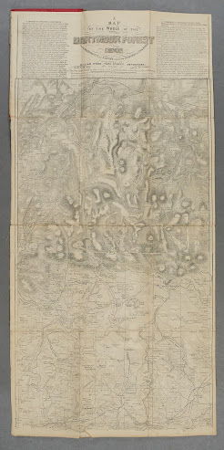
35.1. Title: A Map of the Whole of the Dartmoor Forest, Devon, From Okehampton to Saltram, And from Lydford to Chagford:
Date: [1840]
Size: 340 x 610 mm.
Imprint(s):
Signature(s): Engraved on two adjoining copper plates By John Cooke, Engr. and Geogr Extry to his late Majy in the 75th year of Age.

Comments: The title is top centre of the sheet with text on both sides beginning on the left hand side as A Sketch of Contents of Dartmoor. This finishes below the title and the right hand column is The Principal and Secondary Rivers etc. There is no bottom border to map. The map was reissued at least twice.
William Wood was already using The Environs of Plymouth Devonport And Stone House by Cooke (see 33) at about the same time as this map of Dartmoor was reissued in 1850. The Environs was sold as a folding map in covers before it appeared in his guides, Rambles about Plymouth & Devonport. Given the close proximity of their premises to each other it may be that Wood bought plates from Cooke as he gave up his business.
The map of Dartmoor has been seen with railway completed to Plympton (it reached Cornwood in 1852) and to Launceston (from Tavistock opened 1865). Hence, the dates suggested are to be treated with caution.
Noel Thomas Carrington (1777-1830) was a Devonshire man, best remembered for two poems, The Banks of the Tamar (1820) and Dartmoor (1826):
(Whence is this wondrous Sympathy that draws
Our souls to HOME by its mysterious laws).
Carrington saw service as a seaman on a man-of-war at the Battle of Cape St.Vincent. He later established a school at Plymouth Dock. The British Library only has one edition of his poems published by William Wood, and this is dated 1873, with the book being published in London by Houlston & Sons.
35.2. 1850 Printer´s imprint: PUBLISHED BY WILLIAM WOOD, FORE STREET, DEVONPORT with an advert for an edition of N T Carrington's works: Two Descriptive Poems by THE LATE N T CARRINGTON, in One Volume, Price 4 Shillings replacing the Cooke signature. Bottom border scuffed and unclear. South Devon railway through Plympton.
Illustrated above with title panel illustrated below from a reprint by A Wheaton, publishers of Exeter, for Devon Books in 1965 (copy held by Devon Archives).
Folding map in red covers with plain green label (Price Two Shillings; no imprint on label).
Dartmoor Forest
W Wood. Devonport. (c.1850). DevA, Bod[3].

35.3. 1870 As above: railway to Launceston which crosses border twice. Dotted line from Okehampton (planned line). Generally stronger print. AWNS & DENDLES (Awns today) added on Yealme River. ROBOROUGH replaces JUMP (Ae). Border has been completed below. Below border (CeOS) is Scale 1 Inch to a Mile.
Folding map in orange paper covers. London distributor is Houlston & Sons.
Dartmoor Forest
W Wood. Devonport. (c.1870). DevA, KB.
[1] My thanks to Michael Reckes at ostfrieslandkarten.de. for bringing this edition to my attention (Kart. H 5060). It is reported in IKAR. The date given, circa 1820, is probably too early – see text. My thanks to Anne Leicht for arranging a new scan. Note map was damaged by fire in WW2.


No comments:
Post a Comment